Chicago Streetcar Mystery Photo
For the last several months, we have been hard at work on our upcoming book Chicago Streetcar Pictorial: the PCC Car Era 1936-1958. Here is a picture that is under consideration for the section covering the Madison St. car line. It was taken sometime between 1950 and 1953.
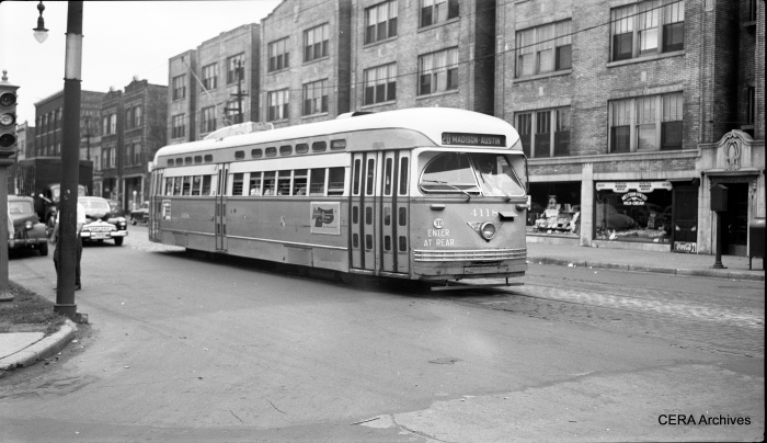
We need your help in figuring out where this picture was taken. We have tried using Google Street View, but unfortunately so many of the buildings along Madison have been torn down over the years that so far, we have been unable to determine the location. Perhaps you can help.
The car is heading west, so the four-story apartment buildings are on the south side of the street. This must be east of Pulaski, too, since Madison gets wider west of there.
If you know the answer, please write to us at: cerablog1@gmail.com
-Thanks!
George Foelschow writes:
I don’t know the answer, but I’ll give a clue. The traffic signal at the extreme left of the photo suggests the cross street is a boulevard. The street light snippet suggests the art nouveau fixtures used in parks and on boulevards. Boulevards intersecting Madison east of Pulaski are Central Park, Sacramento, and Oakley. Ashland would be ruled out because the “Turtle Wax” building would be in the background. The background buildings seem well-kept, which suggests a westerly location. If the store name can be discerned, one could check an early fifties phone directory at the Harold Washington Library.
Roy Benedict comments:
George Foelschow is right on target with the West Park Commission traffic signal and the hanging street light.
The Sanborn maps will solve the whole question. The 9, maybe 10, apartments fronting on Madison would be marked out on the map, probably as a 3B (3-story and basement) building with an unusual footprint including 5 extremely narrow entry courts, about 170 ft. total frontage (based on 1-1/2 line pole spaces of typically 110 ft.). You also have two other 3-story buildings within 330 ft. of the camera and a couple of large buildings beyond. The combination is very unlikely to occur more than one place.
I would suggest looking first at the SE corner of Central Park Ave. because of the unpaved parkway at the extreme left, which suggests to me that it is a park rather than a developed block on the NE corner. All those apartments fronting on Garfield Park would justify the rather elaborate (for the 1920s) detailing of the featured building.
There is a 1950 revision of the Sanborn map on the microfilm set. It is Volume 11 on old series reel 24. My finder does not give detail as to the sheet number.
Second choice would be the SE corner of Homan Ave., where there could be park traffic signals, but not so likely the street lamp and the unpaved parkway.
George suggests other boulevard crossings including Sacramento Blvd., which also is a possibility. I am rather doubtful about Oakley Blvd. with so prestigious and new an apartment block.
If none of that works, the car sign could be wrong. The men sometimes forgot to change the signs. I do not see strong enough shadows to prove the direction of the view. So, the NW corner of a boulevard also is a possibility.
With the load on the car, we do not have to consider the possibility of a pull-out from the Kedzie depot.
Very incidentally, notice the bolted-on car stop band around the line pole rather than the much more common painted ones.
You can narrow down the year by the color of the license plate, but not forgetting the grace period for expired plates.
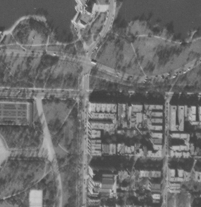
Editor’s note– I believe we have solved the mystery. The correct answer appears to be Central Park Boulevard (3600 w). See the comment below by Charles Amstein. I thank everyone who chimed in with suggestions.
Charles Amstein writes:
I’m nominating the location of W. Madison and Central Park Blvd., opposite Garfield Park, looking southeast.
Attached is a 1951 USGS aerial photo closup of that area.
Note the large block of apartments on the southeast corner, which have indentations matching your photo. Just to the east there is a gap followed by the next 2 larger buildings that correlate with your photo.
1940s Chicago Promotional Film
An interesting 32-minute long promotional film about Chicago, made by the Board of Education in the late 1940s, has surfaced at an estate sale. There are some great views of the city, the “L” at around 3:48, and streetcars at 15:32. You can read more about it here, and watch the movie here.